• New Zealand Regions
      • Hawke's Bay
      • Bay of Plenty
      • Waikato
      • Whanganui
      • Manawatu
      • Northland
      • Auckland
      • Gisborne
      • Taranaki
      • Wellington
      • West Coast
      • Nelson
      • Canterbury
      • Otago
      • Marlborough
      • Southland
      image/svg+xml

      Hawke's Bay

      View Homepage

      Beaches, wineries and Art Deco. The Hawke's Bay has a diverse economy, including business services that support its sectors to be the second largest contributor to regional GDP in the country. A popular tourist destination, the region has some of the countries best restaurants as well as stunning scenery, markets and festivals.

      Districts

      HastingsNapier

      Bay of Plenty

      View Homepage

      The Bay of Plenty is officially New Zealand's sunniest destination, enjoying short-lived winters and long summer days. The Region offers some of the country's most spectacular views and many ways to enjoy the pristine scenery and natural wonders. Visitors also enjoy exploring the Bay's Māori heritage and pre-European roots.

      Districts

      OpotikiOpotiki iSiteKawerauWhakatane

      Waikato

      View Homepage

      The Waikato is known for its rolling plains, fertile land and the mighty Waikato River. The region is the fourth largest regional economy in New Zealand, with a strong focus on primary production and associated manufacturing.

      Districts

      South WaikatoWaikato District

      Whanganui

      View Homepage

      Welcome to Whanganui. This is our place; where history is full of stories, legends and rich legacy. Where a thriving arts scene, creativity and evolving culture inspire our modern lives. Where breath-taking natural landscapes capture imaginations at every turn.

      Manawatu

      View Homepage

      Located in the lower North Island, Manawatu is heartland New Zealand, offering an authentic Kiwi experience.

      The main in the region are Palmerston North, most notable for Massey University. Palmerston has a vibrant, arts and culture scene.

      The region's economy is based on food production and processing, research and education. The region is also home for the New Zealand defence force.

      Northland

      View Homepage

      Northland was originally home to some of our country's first human inhabitants. Today, it is one of the fastest growing regions in New Zealand and home to nearly 189,000 people. Rich in culture and history, the region boasts a stunning natural environment.

      Auckland

      View Homepage

      Auckland Region stretches from the the beaches of the Pacific Ocean in the east to the expansive beaches of the rugged west coast of the Tasman Sea. Auckland City, the largest urban area in New Zealand is considered the main economic center of New Zealand and a popular destination for international students and travellers.

      Gisborne

      View Homepage

      Gisborne is a Region on the east coast of New Zealand's North Island. It's known for wineries and surf beaches such as Makorori. The region has maintained a strong Maori heritage. The region's economy is made up mainly of agriculture, horticulture and forestry.

      Taranaki

      View Homepage

      Taranaki is a coastal and mountainous region on the western side of New Zealand's North Island. Its landscape is dominated by Mount Taranaki, its namesake volcano, which lies within the rainforested Egmont National Park.

      The port city of New Plymouth is the area's cultural and commercial hub. Taranaki's economy is diverse and includes dairy, oil and gas. The region is the highest contributor or national GDP per capita. 

      Wellington

      View Homepage

      The Wellington Region covers Wellington city in the south, Upper and Lower Hutt valleys to the north-east, and Porirua to the north-west. The region takes its name from Wellington, New Zealand's capital city.

      Wellington is famous for its arts and culture scene and is also the centre of New Zealand's film industry.

      West Coast

      View Homepage

      The West Coast, or as some locals call it, the "Wild West", is a long thin region that runs down the South Island's west coast.

      The region has the lowest population in all of New Zealand. It is famous for its rugged natural scenery such as the Pancake Rocks, the Blue Pools of Haast, and the glaciers.

      The main industries in the region are dairy farming and mining. Tourism also plays an important role.

      Nelson – Tasman

      View Homepage

      Nelson Tasman is an extraordinary, vibrant region where art and businesses thrive together among a stunning natural landscape. With one in five people internationally born, Nelson Tasman has 48 different cultures living in its environs.

      The region prides its self on being New Zealand’s leading Research and Development areas, with the highest proportion of people working in the research, science and tech sectors out of anywhere in New Zealand.

      Canterbury

      View Homepage

      Canterbury is a region on New Zealand’s South Island marked by grassy plains, clear lakes and snow-capped mountains. Its largest city, Christchurch, is famed for its art scene and green spaces.

      Otago

      View Homepage

      There are few places in the world which will leave you with a lasting sense of difference. Central Otago is undoubtedly one of them from its landscapes, its seasons, its people, its products and experiences.

      Marlborough

      View Homepage

      Marlborough Region is on the north-eastern corner of the South Island. The region is well known for its winemaking industry, and the Marlborough Sounds, an extensive network of coastal waterways, peninsulas and islands.

      Apart from the wine industry, aquaculture, agriculture and tourism play an important role in the local economy.

      Southland

      View Homepage

      Southland is New Zealand’s most southerly region and includes the World Heritage ranked Fiordland National Park.

      The region's only city Invercargill offers a relaxed pace of life with wide streets, little traffic, spacious parks and gardens, striking Victorian and Edwardian architecture and impressive sporting facilities including New Zealand’s first indoor velodrome. Southland's location is such that views of Aurora Australis or the Southern Lights are common.

      Tooltip

Plans laid out to boost flood protection for Whakatāne CBD

Attention: This article was automatically translated and is still waiting on one of our editors to approve the translated content. 
Share:

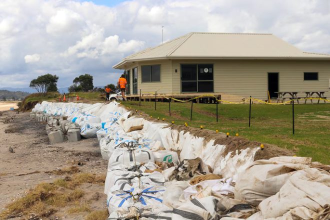
Flood protection for Whakatāne’s town centre is about to get a much-needed upgrade to protect people and property against a one-in-100-year flood.

Project Future Proof has been drawn up to upgrade stopbanks and floodwalls surrounding the central business district and address seepage issues.

It was presented to Whakātane District councillors yesterday by staff from the Bay of Plenty Regional Council.

The council was criticised following major floods in Edgecombe in 2017, where the stop banks failed and more than 300 homes were damaged.

The Whakatāne town centre was less affected, but stopbanks next to Kakahoroa Drive and Quay Street had experienced seepage problems, particularly during the 2017 floods, said project manager Lars Thiel-Lardon.

The presentation outlined how geotechnical investigations, flood data and the effects of climate change have shown up weaknesses in the existing flood defences, which would not protect the town centre in coming decades.

Seepage occurs when water makes its way under the stopbank through the sand layer and begins to seep out slowly onto the ground surface on the protected side.

In extreme cases, such as in Edgecumbe in 2017, ground on the other side can begin to ‘boil’ and be washed-out underneath, which leads to stopbank failure.

This was also seen outside the Quay Street apartments in the 2017 flood.

“As guardians of the stopbanks we need to stop that seepage,” Thiel-Lardon said.

The regional council was investigating several measures, such as inserting steel sheets into the Kakahoroa Drive stopbank and the Quay Street floodwall, to create an impermeable barrier.

This method is used around the world and can be seen in the Kopeopeo Canal near Awakeri.

The council was also looking at moving and raising the concrete flood wall along Quay Street, raising the floodbank along Mataatua Reserve, and using hundreds of hectares of pasture as water detention basins.

None of these options are set in stone.

District councillor Gerard van Beek asked why the regional council was considering sheet piles in the Whakatāne stopbanks when the same method was not considered for Edgecumbe.

Thiel-Lardon said they were not preferred in Edgecumbe because there the pressure would build up leading to a failure, whereas in Whakatāne the sheet piles could be inserted and not hit bedrock.

The large metal sheet piles lengthen the seepage path for excess water to then be pumped back to the river. They also stop the formation of ‘piping’, where water flows through the flood defence picking up foundation material, potentially leading to stopbank failure.

“This is not about stopping the seepage, but rather controlling and slowing it,” Thiel-Lardon said.

Councillor van Beek said the Wairaka community wasn’t pleased the last time the Mataatua Reserve stopbanks were raised, and he wouldn’t be surprised if there was push back again.

He questioned whether the stopbanks on both sides of the river would be raised and Thiel-Lardon said if the regional council raised the stopbanks, it would also raise the reserve and gradually smooth it to “look nice” rather than like a bund.

Stopbanks on the Piripai side of the river might not be raised if other flood protection work was successful.

District councillor Wilson James was concerned about which land the regional council would use to create water detention basins.

Engineering manager Mark Townsend said it would enhance land that already suffered from flooding, so it could hold more water and reduce pressure on the stopbanks surrounding the townships further downriver.

“For example, we could create a series of one metre high bunds; once the water enters one it can then cascade into the next.”

The regional council would complete the work to look as natural as possible, he said.

It is consulting with potentially affected landowners now.

Townsend said if this work was successful, stopbanks might not need to be raised in central Whakatāne.

Deputy mayor Andrew Iles raised concerns that “once again, rural areas are the sacrificial lamb for the urban sector”. But Townsend said the regional council would do its “utmost” to protect any settlement, rural or otherwise.

However Iles said utmost was no guarantee, and Townsend responded that he couldn’t guarantee anything.

At this, district councillor Victor Luca asked to what degree the regional council could guarantee the work.

“We do the best we can using the most up-to-date technology and best practice, but there is no iron-clad guarantee,” Townsend said.

The town defence upgrade is one of the projects aimed at developing better community resilience and flood protection for which the regional council has received funding through the Government’s Crown Infrastructure Partners “shovel-ready” fund.

The fund was aimed at projects able to be undertaken in the short to medium term, to create work and help support economic recovery from Covid-19.

SOURCE: RNZ

Related Articles