• New Zealand Regions
      • Hawke's Bay
      • Bay of Plenty
      • Waikato
      • Whanganui
      • Manawatu
      • Northland
      • Auckland
      • Gisborne
      • Taranaki
      • Wellington
      • West Coast
      • Nelson
      • Canterbury
      • Otago
      • Marlborough
      • Southland
      image/svg+xml

      Hawke's Bay

      View Homepage

      Beaches, wineries and Art Deco. The Hawke's Bay has a diverse economy, including business services that support its sectors to be the second largest contributor to regional GDP in the country. A popular tourist destination, the region has some of the countries best restaurants as well as stunning scenery, markets and festivals.

      Districts

      HastingsNapier

      Bay of Plenty

      View Homepage

      The Bay of Plenty is officially New Zealand's sunniest destination, enjoying short-lived winters and long summer days. The Region offers some of the country's most spectacular views and many ways to enjoy the pristine scenery and natural wonders. Visitors also enjoy exploring the Bay's Māori heritage and pre-European roots.

      Districts

      OpotikiOpotiki iSiteKawerauWhakatane

      Waikato

      View Homepage

      The Waikato is known for its rolling plains, fertile land and the mighty Waikato River. The region is the fourth largest regional economy in New Zealand, with a strong focus on primary production and associated manufacturing.

      Districts

      South WaikatoWaikato District

      Whanganui

      View Homepage

      Welcome to Whanganui. This is our place; where history is full of stories, legends and rich legacy. Where a thriving arts scene, creativity and evolving culture inspire our modern lives. Where breath-taking natural landscapes capture imaginations at every turn.

      Manawatu

      View Homepage

      Located in the lower North Island, Manawatu is heartland New Zealand, offering an authentic Kiwi experience.

      The main in the region are Palmerston North, most notable for Massey University. Palmerston has a vibrant, arts and culture scene.

      The region's economy is based on food production and processing, research and education. The region is also home for the New Zealand defence force.

      Northland

      View Homepage

      Northland was originally home to some of our country's first human inhabitants. Today, it is one of the fastest growing regions in New Zealand and home to nearly 189,000 people. Rich in culture and history, the region boasts a stunning natural environment.

      Auckland

      View Homepage

      Auckland Region stretches from the the beaches of the Pacific Ocean in the east to the expansive beaches of the rugged west coast of the Tasman Sea. Auckland City, the largest urban area in New Zealand is considered the main economic center of New Zealand and a popular destination for international students and travellers.

      Gisborne

      View Homepage

      Gisborne is a Region on the east coast of New Zealand's North Island. It's known for wineries and surf beaches such as Makorori. The region has maintained a strong Maori heritage. The region's economy is made up mainly of agriculture, horticulture and forestry.

      Taranaki

      View Homepage

      Taranaki is a coastal and mountainous region on the western side of New Zealand's North Island. Its landscape is dominated by Mount Taranaki, its namesake volcano, which lies within the rainforested Egmont National Park.

      The port city of New Plymouth is the area's cultural and commercial hub. Taranaki's economy is diverse and includes dairy, oil and gas. The region is the highest contributor or national GDP per capita. 

      Wellington

      View Homepage

      The Wellington Region covers Wellington city in the south, Upper and Lower Hutt valleys to the north-east, and Porirua to the north-west. The region takes its name from Wellington, New Zealand's capital city.

      Wellington is famous for its arts and culture scene and is also the centre of New Zealand's film industry.

      West Coast

      View Homepage

      The West Coast, or as some locals call it, the "Wild West", is a long thin region that runs down the South Island's west coast.

      The region has the lowest population in all of New Zealand. It is famous for its rugged natural scenery such as the Pancake Rocks, the Blue Pools of Haast, and the glaciers.

      The main industries in the region are dairy farming and mining. Tourism also plays an important role.

      Nelson – Tasman

      View Homepage

      Nelson Tasman is an extraordinary, vibrant region where art and businesses thrive together among a stunning natural landscape. With one in five people internationally born, Nelson Tasman has 48 different cultures living in its environs.

      The region prides its self on being New Zealand’s leading Research and Development areas, with the highest proportion of people working in the research, science and tech sectors out of anywhere in New Zealand.

      Canterbury

      View Homepage

      Canterbury is a region on New Zealand’s South Island marked by grassy plains, clear lakes and snow-capped mountains. Its largest city, Christchurch, is famed for its art scene and green spaces.

      Otago

      View Homepage

      There are few places in the world which will leave you with a lasting sense of difference. Central Otago is undoubtedly one of them from its landscapes, its seasons, its people, its products and experiences.

      Marlborough

      View Homepage

      Marlborough Region is on the north-eastern corner of the South Island. The region is well known for its winemaking industry, and the Marlborough Sounds, an extensive network of coastal waterways, peninsulas and islands.

      Apart from the wine industry, aquaculture, agriculture and tourism play an important role in the local economy.

      Southland

      View Homepage

      Southland is New Zealand’s most southerly region and includes the World Heritage ranked Fiordland National Park.

      The region's only city Invercargill offers a relaxed pace of life with wide streets, little traffic, spacious parks and gardens, striking Victorian and Edwardian architecture and impressive sporting facilities including New Zealand’s first indoor velodrome. Southland's location is such that views of Aurora Australis or the Southern Lights are common.

      Tooltip

Chuyến đi cuối cùng để khám phá bí mật dưới bề mặt

Attention: This article was automatically translated and is still waiting on one of our editors to approve the translated content. 
Share:

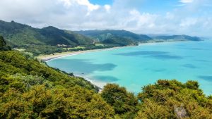
Tàu nghiên cứu Tangaroa đã bắt tay vào hành trình cuối cùng để nghiên cứu hệ thống núi lửa của núi lửa đảo Whakaari/White và Tūhua/Mayor. Đây là một phần của chương trình Beneath the Waves do GNS Science dẫn đầu. Mục đích là để hiểu sâu hơn về các tác nhân, mối nguy hiểm và tác động của các sự kiện núi lửa tiềm ẩn như tro bụi, luồng nhiệt, sạt lở đất và sóng thần.

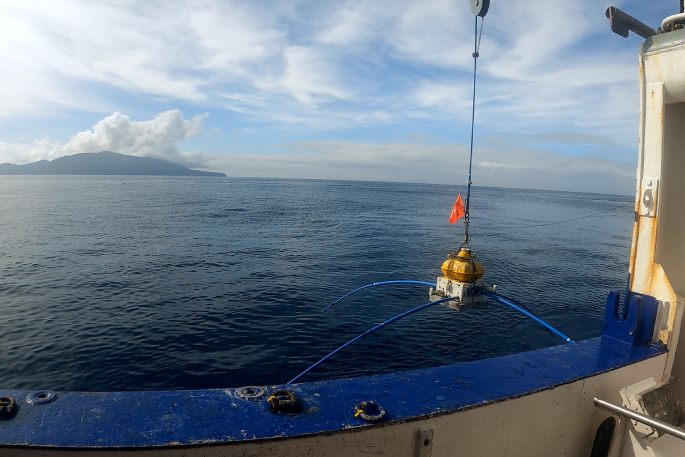
Các nhà khoa học từ GNS Science, Viện Hải dương học Scripps và hai Đại sứ BLAKE GNS sẽ lắp đặt 39 trong số 200 cảm biến Điện từ đáy đại dương còn lại từ ngày 28 tháng 3 đến ngày 12 tháng 4. Các cảm biến này sẽ cung cấp hình ảnh của các hệ thống magma cung cấp năng lượng cho núi lửa và xác định các khu vực thông hơi thủy nhiệt hoạt động.

Các chuyến đi trước đây đã cung cấp thông tin mới về tần suất, kích thước và nguyên nhân của các vụ phun trào trong quá khứ, theo Craig Miller, nhà địa vật lý núi lửa cao cấp của GNS Science và trưởng nhóm chương trình. Phân tích ban đầu cho thấy bằng chứng về chất lỏng sâu, có thể là magma, ở phía tây bắc của Whakaari. Nếu đúng, điều này có thể ảnh hưởng đến cách núi lửa được theo dõi trong tương lai. Hoạt động địa chấn trong khu vực này có thể cho thấy hoạt động núi lửa gia tăng.

Kết quả sơ bộ từ các mẫu trầm tích đáy biển cho thấy các vụ phun trào lớn hơn trong vài nghìn năm qua so với các vụ phun trào được ghi nhận từ những năm 1800. Nhóm nghiên cứu hiện muốn điều tra xem liệu những vụ phun trào này có đủ lớn để đưa tro đến đất liền hay không.

Dữ liệu từ các cuộc khảo sát dưới nước trước đây đã xác định các vị trí của hoạt động thủy nhiệt trước đó và sự thấm nước hoạt động dưới nước của chất lỏng thủy nhiệt. Những phát hiện này, cùng với các cuộc khảo sát trên không được thực hiện vào đầu năm 2023 bằng hệ thống SkyTem, giúp lập bản đồ hoạt động thủy nhiệt trong quá khứ và hiện tại trên toàn bộ ngọn núi lửa. Thông tin này được sử dụng để tạo ra các mô hình 3-D chính xác cho thấy các khu vực đá bị suy yếu và nơi xảy ra sạt lở đất trong quá khứ. Điều này rất quan trọng vì lở đất có thể gây ra một vụ phun trào hoặc gây ra sóng thần.

Craig nói: “Hình ảnh dưới bề mặt đang góp phần vào các mô phỏng và mô hình số mạnh mẽ mà chúng tôi đang bắt đầu sử dụng để đánh giá nhiều kịch bản có thể xảy ra cho Vịnh Plenty từ các sự kiện núi lửa trong tương lai. “Nếu chúng ta có thể xác định xác suất và tác động của những mối nguy hiểm núi lửa này, chúng ta có thể chuẩn bị tốt hơn cho chúng khi chúng xảy ra.”

Chương trình Beneath the Waves là một sáng kiến do GNS dẫn đầu được thực hiện với các cộng tác viên từ các trường đại học và các tổ chức quản lý khẩn cấp khác nhau.

Related Articles